 By Amy Schindler
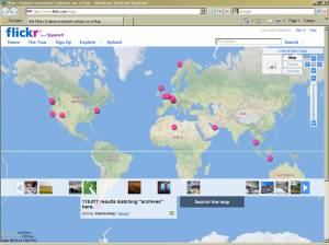
Geotagging, also known as geolocation, is the adding of geographical identification data to images, videos, websites, Twitter tweets, and other media. Geotagging allows users to find location-specific information including news, images, and other content. Using geotagging with tools like Flickr will also allow you to find others in your geographic area using the site who you may wish to share content with, add as a contact, or just learn more about.
Tasks
- If you have added images to Flickr, return to the images and add a location: click Organize & Create > Most recent upload > Location > Add items to the map. There are also directions from a Flickr Help Screencast video.
- After adding locations to your images, it is time to explore who and what is nearby: click Organize & Create > Your Map > Zoom in & out as needed clicking on others’ images. As you view the images added to the map near your own, consider adding the creators as contacts.
Advanced Task
- Turn on geotagging for your Twitter account (at least temporarily): go to Settings > Enable geotagging. Tweet.
Blog Prompt
- In what ways could geotagging be useful to your repository and potential users of your collections?
Resources
- Geotagging and Facebook: Facebook Community Page about “Geotagging”.
- Geotagging and Flickr: “Flickr Geo Tagging Now Live”, by Michael Arrington on Tech Crunch (August 28, 2006).
- Geotagging and Twitter: “Think Globally, Tweet Locally” on the Twitter Blog, “Twitter Geotagging: What you Need to Know”, by Ian Paul on PC World (November 20, 2009), and “Why Twitter Wants to Know Where You Are”, by Jennifer Van Grove on Mashable.com (January 23, 2010).
- “Really Cool Ways to Browse Flickr (and Waste a Lot of Time)”, NPR (May 1, 2009).
- “Library of Congress Looks for Help on Photo Labels,” NPR Morning Edition (January 21, 2008).
- “Geotagging” and “Geosocial Networking” articles on Wikipedia
- “7 Things You Should Know About Geolocation,” an EDUCAUSE article from 2008.
